Translate

Friday 27 November 2015

How to beat Black Friday..........November 27th.(Northumberland Coast)
    There are many things that come out of America that I like, rock n' roll, jazz and cowboy films, plus a lot of other films. There are some things we have imported from the US I don't like, such as Halloween and Black Friday, that day when the stores open early and people fight over TV sets.
    One of the lady columnists for The Times offered ten ways of avoiding the madness;
1.  Stay at home, 2, Stay at home.....................10. Stay at home.
   With over 500 years of collective wisdom eight gadgies came up with our own way of avoiding mayhem in the malls; go for a walk.
A full squad out too; Dave, Brian, Ben, Harry, Ray, John C., John H., and me (Note the Oxford comma)
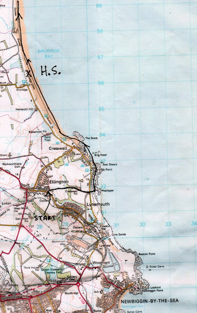
     Sadly the long awaited walk from Middleton in Teesdale  (now abbreviated to M i T) has had to be postponed again because we are promised heavy rain in the afternoon  so the octet have opted for another walk up the Northumberland coast, from Ellington to Amble.
  Ellington is an ex mining village close to the sea. Until 2005 the coal it produced powered the Lynemouth power station which in turn powered the Alcan smelter across the road. The mine has closed, the smelter has become the home of small industry. One of the miners has become MP for the area.
           Memorial statue to the men and mine at Ellington.

To get to Ellington from Newcastle take the Northumberland Spine road (A189) and follow signs through Lynemouth. As you enter Ellington there is a road on the right with parking space.
                                    This week's car park in Ellington.
  It is an easy walk, no map required but should you wish it is covered by OS Landranger 81 Alnwick, Morpeth.
  It was, for November, a mild and pleasant morning with a light wind from the south west, on our backs all the way. Continuing down the road where we had parked we past Cresswell Farm, the buildings were being converted into homes. A large dog greeted us.
 He is playing for Newcastle United next week, won't let go of the ball.
   At the end of the track we crossed the dunes and tuned north. The beach in this area is covered with rocks of different sizes and seaweed, making it slippy. The beach is covered in places by coal dust that seeps out of the seams. The rocks are probably interesting for geologists and geography teachers, layers of sand stone.


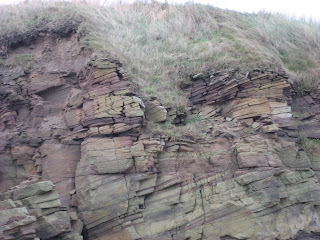
                                                   Today's Geology lesson.

 But soon we were back on land as we walked through Cresswell, the spring where watercress grows. Most of the houses appear to be holiday homes, apart from this one.
                                    Cresswell tower and a strand of barbed wire.
   Beyond Cresswell we were back on the beach, walking the curved Druridge Bay, about five miles of it. Not much bird activity on the beach today, sanderlings and gulls, plus a cormorant although Ben and Dave claimed a kingfisher as we had walked towards the sea from Ellington.
After about five miles walking it was time to hunker down below the sand dunes for a Herbie Spot.


                                                 Today's goodies included Cherry Bakewells, Tracker bars, ginger biscuits from Ben, chocolate flapjacks and mincemeat flavoured cake from Mrs A. The stuff you put in mince pies, not meat.
                        The blocks are left overs from WWII, designed to stop tanks landing
                              A slightly choppy sea
                               Miles of golden sands
Lunch over we continued north, leaving the beach at Low Hauxley. There is a nature reserve here, access from the land side. Several hides and a centre under reconstruction after an act of pointless vandalism set the old one on fire.
                                      Hauxley Nature Reserve  centre under construction
From Hauxley we followed the narrow footpath that climbed up and down the dunes. Eventually we reached Amble, Northumberland's Friendliest port and found the bus stop.
                                                  Amble
                                   Warkworth Castle is not far from Amble.
                 As we waited in the shelter for the bus the promised rain arrived, heavy and driven by the wind. Had we spent much longer over lunch we would have been  very wet gadgies. Back in Ellington we hurriedly debooted and headed for the Three Horse Shoes at Horton. A large pub with a large selection of beers including Abbott, Golden Shoes and Hadrians Border.
                                      The three Horse Shoes,good pub, good beers, good food. Five barrells.

The Matrix MMXV  YYYY
                                                                           steps                       miles
Nako                                                                  26413                      10.39
LIDL3D                                                            23895                       10.18
etrex                                                                                                   11.1

Dave's LIDL3D                                                23660                        10.88
  "        USB                                                      23271                         11.38
Nako                                                                 24272                         11.87
John C                                                                                                  11.3
Brian                                                                                                     11.4


Contains OS data, copyright. Crown copyright and database right 2015.

Wednesday 25 November 2015

The follies of men...................November 24th.(Northumberland)
   Another mid week walk of archaeological interest for me and Dave. We are having a walk from Scots Gap in Northumberland to visit some old and some ancient sites.
  I have no idea why it's called Scots Gap, maybe drovers brought their cattle through here in olden times. It is not the prettiest of villages; once stopping place on the Wansbeck Railway line with a cattle market the most interesting fact we could find was that there is one bus a week, on a Wednesday, that goes to Albemarle Barracks on the "Military Road" and one bus a week, also on a Wednesday that goes to Morpeth. Passengers for these two buses have substantial bus shelters.
 To get there from Newcastle we took the A696 through Ponteland to Belsay, turned right towards Bolam Lake and past the lake, took the B6343 to Scots' Gap. Through the village on the right there is a National Trust Office with a car park.
                                              National Trust office and car park.
The walk:  OS  OL Explorer 42 Kielder Water and Forest
Heading back east through the village we found the finger post on the left pointing up the track past Grangemoor Farm and continuing in a straight line to the wooded valley of the Hart Burn which we crossed using the footbridge, there being quite a depth of water flowing over the ford.
                                               The Hartburn from the footbridge.
  We followed the footpath going through or near to Rothley Lodge, Rothley Mill and Rothley Mill Farm, most of the buildings appearing to having been converted to houses for permanent occupation or maybe holiday homes.
 Once past the houses we headed almost due north on a farm track alongside a couple of fields to reach Rothley. From here we followed the posted path across a field before leaving it and walking up to the first target of the day, Rothley Castle.
 This folly was built about 1755 for Sir Walter Blackett as a viewing point for his deer park. It does look like a ruined castle.

Every deer park needs a folly. Rothley Castle.
Close by it is possible to see the outlines of an Iron Age/Romano British Hill fort and between the two is the site of a WWII searchlight station but we saw no evidence of that.
Dave points out part of the ancient ramparts. High above the surrounding country, a good site.
Back down the hill we rejoined the footpath alongside a well built wall and followed it to a junction where we turned left and headed almost due north on a track next to a plantation until we came to a road.
A bit naughty here, rather than walk on the road going west we battled, without machetes, through the rhododendrons of  "North Strip" before crossing a fence or two into a field and walking up to "Codgers Fort". Supposedly built to defy the invading army of the Bonnie Prince in the '45 uprising, it was actually built in 1769, again for Sir Walter. It is on a craggy hillside and made a fine Herbie Spot, out of the wind but in the sun. Treats were limited, there being only the two of us, we had almond slices and the remains of  flapjacks from www.cakepoppins.co.uk .
                Codgers Fort, highly appropriate, Codger is a word similar to Gadgie in meaning.
 Lunch over we headed across the fields in a north east direction until we hit a farm track and turned left, around the end of Rothley Lake, built by damming a stream and used as a fishing lake by Sir Walter when he was tired of his deer park. The track joins the dismantled railway line which we followed to the road.
                                                        Rothley Lake
 At this point we turned naughty again and climbed a wall to bring us back onto thje railway line. At this point it is not a right of way, we risked the chance of an ASBO however and followed it, partly in cuttings, partly on embankments as the line curved round Rothley Lake Nature Reserve, probably not built by Sir Walter.
 At Dell Burn the railway line becomes part of the Wannie Line Country Walk and we felt a little safer as we were legal, although without the blessing of British Rail.


                                            But you may walk along it.
  We followed the line, just before  Scots' Gap there is a junction where another line once headed west. Soon we were back at the National Trust office after a pleasant and interesting wander round Northumberland, a walk that can be extended.
It was a good day for birds too; kestrels, treecreeper, great tits, blue tits, redwings, fieldfares ravens and a buzzard sitting on a bench by the side of the road.

The Matrix MMXV  YYYY
                                                                            steps                                  miles
 Nako                                                                23507                                10.01
LIDL3D                                                           22256                                  7.7!!!!!!!!!!!!!
etrex                                                                                                             8.4
OUTDOOR GPS                                                                                         8.2

Dave's LIDL3D                                              18970                                   8.72
  "        USB                                                    18082                                   8.27
  "          Nako                                                  21600                                   9.88

We claimed 8.4
         

Friday 20 November 2015

Belford, Beacons, Bays and Bamburgh...Nov 20th.(Northumberland)
Belford is a village in north Northumberland with a population of about 1500, a church dating back in parts to the 13th century, several pubs and a small railway station. The name means either "Bella's Ford, "settlement on a bell shaped hill" or " a glade near swampy ground. Take your pick. It is however the starting line for today's walk, a p;opular one covered several times in the blog but never in The Times "A good Walk". The forecast has once more postponed the trip to Teesdale, or even the Northumbrian hills. The second storm has been, the Met Office called it Barney because they thought it might produce some rubble!
It's a real gadgie walk because we are driving to Seahouses and catching the X18 or 418 to Belford. An infrequent service if you want to uise it, check timetables available on the Nexus site.
To get to Seahouses, A1 north beyond Alnwick, turn east and follow signposts on minor roads. There is a large car park on the site of the old railway station, a gear shop in case you have forgotten your socks, and several fish and chip shops.
The team today; John C., Brian. Ray, Harry, Dave and me  the blogmeister. Which reminds me, I got a note from a gentleman who liked the interesting but redundant gate post last week. He directed me to photos of several others near Skipton in Yorkshire in the area I was born. There were also some Green Lane markers (qv). Dave the archaeologist was interested too.
I have no idea why it turned blue.
Should you need a map for the walk the one to use OS Explorer 340 Holy Island.
We arrived in time for tea at Trotters Bakery and Cafe on Seahouses High Street, a bacon sandwich was awarded 3.5 flitches, the tea was fine and the staff were friendly. We caught the 11am bus and got off at the Golfclub in Belford to start the walk.

                                       Belford main street, St Mary's church.
 A sign post for St. Oswald's Way (again!) pointed us on our way alongside Belford Burn, next to the golf course. Soon we came to the A1, major road on the east side of Britain between London and Edinburgh.
                            The A1 in a quiet moment. A single carriageway. Had it been in the south it would have been duelled  years ago if not upgraded to motorway standards, but it is in the north so it doesn't matter. Perhaps the conservative MP for the area can persuade the government to get on with improving it.
  Across the road we followed the footpath alongside the grain silos, Northumberland is an agricultural county producing wheat, barley and root vegetables, plus a few leeks for show.
     The silos near Belford. There is a heating system to dry the the crop, Brian feels it goes against the grain and he should know, he studied agriculture.
 In the field  by the silos was an interesting but small flock of sheep, possibly Jacob's, or maybe belonging to somebody else.
                                                  Jacob's sheep.
  Next stop the railway; it is the main line between London and Edinburgh and there is a pedestrian crossing here. You are asked to use the phone by the gate to ask permission to cross, we did, and once over we phoned from the other side to tell the signalman we were safely over the lines.
The footpath crosses a stretch of old and rusty track that once served the nearby Easington Quarry, crosses a couple of fields in a very straight line and emerges at a minor road. On previous occasions we have followed the road to the right past the dovecot but today we turned left, leaving the holy man's way and walked down the road a short distance.

A distant view of the Outchester Ducket or dovecot. Built for feed storage and for keeping doves it is now a holiday cottage.

                                   The ducket on a sunny day. It may, says the archaeologist, be built on the site of a Roman Camp.
 Near a cottage we found the sign post on the right leading us to Waren Mill.
                                                     Sign post for Waren Mill.
The footpath crosses a couple of fields, muddy today like most of the fields we have crossed  before coming to the road at the mill.
Waren Mill is ancient, a plaque on the wall says it had links to Bamburgh Castle and gets its first mention in 1187. originally water powered it started to use steam in 1819. being close to Budle Bay it could import coal and export milled grain. It finally closed as a mill in 1984 and is now a block of flats, sorry, luxury apartments.
                                                    Waren Mill
                              Budle Bay on a grey day with the tide out and lots of ducks on the mudflats. North of Budle Bay on Ross Sands there is a Naturist Beach, probably too cold for that today! And beyond that are two stone built Navigation Towers, 500 feet apart, built between 1820 and 1840.
Navigation towers north of Budle Bay. They are 500 feet apart. I have tried to explain to my wife that this can not be exact because it is  continuous and not discrete but she says I am being silly.

Just beyond the hamlet we went through a gate onto the shore and walked along the soft sand for a couple of miles before we came to a derelict pier which made a fine shelter against the cold north west wind. We declared a Herbie Spot.
    A bit low on treats today, almond slices, flapjacks from www.cakepoppins.co.uk and chocolate and beetroot muffins from Mrs A. There are still some who will not join in the exchange of goods. Shame on them.
Break over we continued along the beach, rounding Budle Point  and passing the light at Blackrocks Point. Stag Rock is nearby, so called, according to Brian in a long rambling tale, because it was painted in the days of King Arthur bu Lancelot when, on his wedding eve, he invented the stag party.
                                The light at Blackrock Point
                             An early work by Sir Lancelot, impressionist style and minimalist in use of colour.
Rounding the point we came to the finest looking castle in Britain if not Europe, Bamburgh.
It has ancient foundations and a Norman Keep. It featured in a recent film of Macbeth and had a magnificent mountain painted in digitally behind it. The film was pretty good, the Scottish soldiers looked ill throven and badly dressed, not a Hollywood quif between them.
                                    Bamburgh Castle, Northumberland. Built on the Whin Sill it was a Saxon Fort, a Norman Keep and a film star.
Passing the castle  we continued on the beach all the way into Seahouses where, having changed, we refreshed ourselves at the Olde Ship Inn which had a variety of beers, Speckled Hen, Directors, Theakstons, Farne Island and the cheeriest bar maid we have seen in years. Very much a locals pub, be careful where you sit.
Not a bad day for the birders, ducks, waders and a kestrel, but it was a windy day, best stay in your nest lads. Harry and Brian spotted the bird of the blog though, a little auk.
Little Auk, nothing like the big ones in "Lord of the Rings"


                                     The Olde Ship Inn, Seahouses.
The Matrix MMXV  YYYYY
                                                                        steps                         miles

LIDL 3D                                                        21405                        8
Nakosite                                                         21316                        9.0
Dave's LIDL 3D                                            19205                        9.4
""        USB                                                    18716                        9.15
Nakosite                                                         18611                        9.10
etrex                                                                                                  9.3
John C                                                                                               9.44
Brian                                                                                                 9.1
Settle for 9.2


Contains OS Data, Copyright. Crown Copyright and Database right 2015

Friday 13 November 2015

Whittlesnittering in Northumberland..Nov13th (Obvious)
   Whittlesnittering is almost a lost skill in Northumberland. Back in the days when agriculture was horse-powered a farm labourer, usually the youngest, was given the task of cleaning the clarts (qv) from horses hooves before they were re shod, especially if the ground had been really claggy. (qv too). As it was not a glamorous task it has rarely been seen at village fairs, unlike sheep shearing, sheep dog trials and pony-riding. Perhaps one day it will make a comeback.
You can see how well the Whittlesnitterer has done his work in this photo, a neat pile of clarts.

  The British Meteorological society has a gentle sense of humour. Older Britons will well remember the unfortunate BBC weatherman, Michael Fish, using information from the Met Office, telling the nation there was no truth in the talk of a great storm one night in October 1987. That night over four million trees were uprooted or blown over in the south of England leading to a rise in the sales of wood burning stoves and artisan furniture.
  This year the Met Office has decided to follow the practice of other countries and give names to storms as they approach. The first, scheduled to arrive on Thursday night, November 12th, has been called Abigail. How subtle is that, A Big Gale. In future we can look forward to Harry Kane or Teresa Felling.

Today's walk round Teesdale has been postponed, mainly thanks to Abigail, and we have chosen a more sheltered walk from Rothbury, country town in Northumberland. (A1 north, A697 and follow the diversion signs, the road has still not been fully repaired since it was washed out two years ago.)
Six of us out, Ben, Brian, John H,, John C., Dave and me, two cars and meeting for breakfast in Tomlinsons cafe and bunkhouse on Bridge Street, Rothbury. A top cafe, good food, including beer and wine if you want, a bunkhouse and some books on local interest and walks for sale.
The walk:
A map is more than useful on this walk although much of it is well marked. The map to use is OS Explorer 332 Alnwick and Amble. We started at Tomlinsons cafe, there is limited parking on the street and there is a car park across the river.

Still there although the Tour of Britain is long gone.


                              www.tomlinsonsrothbury.co.uk
        From the cafe we walked up the hill, past the church and onto Rothbury High Street. Easily recognised it is very wide and lined on the north side with proper shops. Look out for an alleyway or ginnel on the north side, there is no signpost but a notice tells you the Cooperative Funeral Service is at the top. The alley is quite steep, the Grisdale of Rothbury. At the top we turned left on the road and then almost immediately turned right, still climbing up a lane past several bungalows. At the end of the lane the footpath enters a wood, still climbing too, and slippy after much overnight rain. Once out of the wood we took the right fork in the path and headed across boggy moorland before entering the Primrose Wood plantation.


Walking through the sun dappled woods.
                                                                                                                        Look out for an old trailer on the left, it has been there for years. We turned left at the forest road and leaving the primrose path headed north to Crocky's Heugh. (A heugh is a hill or cliff, not to be confused with a haugh, which is a bit of flat land by a bend in a river. You could have a haugh below a heugh!). We followed the track across the moor until, near a wall, we spotted a signpost that took us on another muddy, boggy path heading north up and over Cartington Hill, mostly interesting for its three cairns, in a straight line.

                                                Cartington Hill only about 980 feet high.
At the end of the summit plateau we followed a path going west that is not marked on the map. It led to a gate marked "Private No Access" but as none of us can read we went through, joined a farm track and soon arrived unmolested at a road turned right and walked on to Bankhead. At the farm it started to rain, courtesy of Abigail, and we stopped to don waterproofs.
                               Cloud covered Cheviot. A scattering of snow visible when it was clear.


At Bankhead we turned left down a farm track and crossed several fields before reaching the farm at Whittle. Whittle means white hill. It is a fine looking farmhouse with a friendly collie guarding the gate.
         Whittle farm, the dog had turned to call his agent                                                                                              The footpath is well marked with little yellow arrows on white discs, easy to follow.
 We followed the footpath alongside a field sown with winter wheat already showing before turning right across the field and entering a wood, crossing Blackburn by a footbridge. On the edge of the wood we called a Herbie Spot.
                        Caught in the sunlight. Today's treats included Ben's ginger biscuits, almond slices, flapjacks from www.cakepoppins.co.uk, Corbyn cookies aqnd apple muffins from Mrs A. The apples game from the Algar garden.
Lunch over we headed south of west along the edge of a field before turning left and crossing more fields until we reached Snitter.

           Snitter, a hamlet. Nothing to do with cigars or sad Danes it is a settlement without a church. The name Snitter means a blast of icy snow.
  For years English teachers have told their pupils that the Inuits do not have a word for snow but have seventeen  words to describe different types of snow. Google it and you will find the teachers are wrong. Inuits have words as we do to describe different forms of snow, like sleet presumably. A recent dictionary of the Scottish language claims the Scots have over four hundred words to describe snow!
  We turned right along the road going north west out of the village and then almost immediately turned left again, crossing more fields, pausing  only to look at an interesting gatepost before reaching a road.
                      An interesting, if redundant gatepost.
  After walking a short distance on the road we came to Thropton. The footpath to Rothbury is not too obvious. Look for the Recycling Area and walk down the lane. It is on the right of the main street. Halfway down the lane is a signpost telling you you are on the right track. The footpath crosses the river Coquet and wanders across fields before joining a good path which leads to another footbridge.

                                        River Coquet near Rothbury.
 Back on the north side of the river the well made footpath leads back towards Rothbury. Look out for a set of narrow steps near the car park, they lead back to the church and Tomlinsons.
On the way home we visited the Anglers Arms which was selling Taylors Golden Bitter and Bombardier, the Speckled Hen had just been finished.

MATRIX MMXV    YYY
                                                                         steps                              miles
Nakosite                                                          27594                            12.56 (needs adjusting)
LIDL3D                                                          24718                            8.45       "           "
Dave's 3D                                                       22220                             10.21
USB                                                                21543                             9.86
Naosite                                                            21412                             9.8
OUTDOOR GPS                                                                                   10.1
etrx                                                                                                        10.13
Ben                                                                                                        10

settle for 10 then.

Abigail was like a baby, a bit wet and windy. And we saw a heron
Aw come on, you didn't really believe it did you?